Ōrākei basin info graphic
This is a new project that I'm prototyping, looking at ways to explore themes alongside each other (in this example including urban design, conservation and accessibility).
So far I've created:
- A handpainted, tactile image illustrating waterways plus selected features of the current and proposed built environment.
- A written "walk-through" of the same area, described with reference to map orientation and well-known landmarks.
Care and sensitivity
These topics given current events and the economy, can be heavy for some - especially those most directly impacted.
Remember to prioritise your own and others overall wellbeing, and find ways to keep things sustainable and positive, whatever that looks like for you.
First draft
Prototyping means starting out and looking for feedback - this is a first draft, so will have room for improvement and iteration - I can already think of plenty!
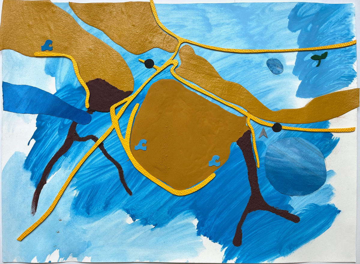
Features shown are: waterways and sewage overflow areas, proposed wastewater project area, accessible routes, train stations, potential urban development zones, water recreation spots, and māra kai.
Original hand painted graphic, 76cm x 56cm.
Acrylic, sand & various recycled materials on 300GSM watercolour paper.
Written walkthrough - map text version
-
Starting position and orientation
To begin, imagine that you're standing at Meadowbank train station, facing North.
- The train tracks cross left to right in front of you, just beyond is the waterway.
- Going up the hill are Pourewa Community Hub & māra kai.
- Then Kepa Rd, with a small area zoned for Urban apartments.
- Beyond into the distance, there's Ngāti Whātua Ōrākei marae at the top of the hill.
Turn to face East
- The train line, and Te Ara ki Uta ki Tai (the path of land & sea) shared path continue towards Glen Innes.
- Relatively close is a large area of Meadowbank zoned for Urban apartments (with some caveats).
Turn to face South
- A waterway comes out of Ōrākei Basin and branches South (this area is sometimes affected by sewage overflows).
- A narrow walkway follows the waterway, with some parts accessible.
Turn to face South-west
- Close by, steps and a bridge go across the waterway.
- Remuera is off in the distance.
Turn to face West
- Once you’ve crossed the bridge and gone over the hill (lots of steps), an accessible walkway goes around most of Ōrākei Basin.
- Looking across the basin, the Water Ski Club is positioned at the closest edge.
- On the far side of the basin are the boat club (and ramp) and a Safeswim site.
- In the middle distance, Ōrākei Road goes up towards Remuera.
Turn to face Northwest
- Across Ōrākei Road, are more areas where sewage overflows affect the waterways (and the site of the proposed Newmarket Gully Wastewater project which would take care of these).
- Then there's Hobson Bay, with an accessible walkway towards Te Tinana beach & Safeswim site (this area is also sometimes affected by sewage overflows).
- Turn a bit further North, and you'll be facing Ōrākei train station, with accessible access that links to Te Ara shared path and the big shared walk/cycle bridge across the basin to Meadowbank.
- Off in the distance are Parnell baths, Judges Bay, the central city & Waitamatā harbour.